Despite varying beliefs in climate change, there is no denying the fact that wildfires worldwide have increased in recent years. There’s the ongoing wildfires in Canada today as well as the megafire in Australia in 2019-2020, as two prominent examples. To bring it closer to home in the U.S., there were the California wildfires in 2018 that recorded almost 8,000 wildfires in the state.
Unfortunately, it’s only going to get worse. The U.N. is predicting a 14% increase in global wildfires by 2030, rising sharply to 30% by 2050 and 50% by the end of the century. These stats are there to prompt public sector organizations around the globe to revolutionize the way in which they are assessing wildfire risk.
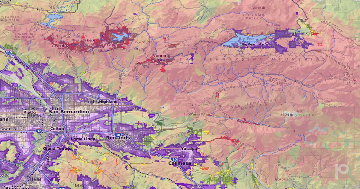
With California itself seeing a sharp increase in wildfire activity over the past few decades, San Bernardino County, knew it needed to act swiftly to help protect its population of over 2 million residents.
To do that, The Mountain Rim Fire Safe Council in San Bernardino County, California relies on Precisely’s Wildfire Risk product to strengthen local wildfire protection plans and help manage risk to property and citizens. The county-wide data is provided to the fire safe council via a pro bono product initiative spearheaded by the ESG Commission at Precisely.
“Being able to show a citizen their home on a map, and the risk associated with that area, has a powerful impact on fire stewardship within the community, further reducing the risk of wildfire damage,” said Laura Dyberg, president at Mountain Rim Fire Safe Council. “With tangible data to back it up, our grant applications are immeasurably stronger and more accurate forecasting allows us to better educate and prepare residents.”
Wildfire Risk is an advanced and contemporary database that assesses the likelihood and danger of wildfires. The system takes into account a range of factors, including geographical features, climate conditions and human influences. These factors consist of slope, orientation, vegetation type, historical burn patterns, distance to water sources, specific wind-prone regions density of non-flammable surfaces, and proximity to fire stations.
As a result, the system generates a unique collection of customized fire zone polygons that cover the entire U.S., each accompanied by its corresponding risk score. Additionally, all data is accessible at the individual address level through a distinct identifier, providing additional measurements of proximity for a deeper understanding of structure-specific risks.
Advantages:
- Evaluates exposure to wildfire risks using a model tailored to the unique characteristics of each landscape.
- Optimizes profitability by avoiding high-risk areas while identifying potential opportunities within generally hazardous regions.
- Gathers insights on wildfire risks at the property level (rather than relying on broad regional assessments), thus enabling more accurate pricing strategies.
- Measures a property's proximity to zones with high and very high wildfire risks, as well as its distance from the interface between wildland and urban areas.
“The Precisely Wildfire Risk product is developed by a team of seasoned fire scientists with real wildfire expertise, ensuring that the methodology and models reflect the most accurate and reliable data in the market,” said Dan Adams, Senior Vice President – Data Enrichment at Precisely. “It’s humbling to see the impact that access to trustworthy wildfire risk data has already had in San Bernardino County.”
Precisely is further expanding its partnership, working with San Bernardino to explore how the Precisely data enrichment portfolio can continue to help inform and enrich policymaking across several additional parts of the county.
Edited by Alex Passett